Cultural Crossroads a COPLAC Digital Course

Month: October 2017

Video Trouble

As I was creating a page on the Irish Famine on our project site I ran into some trouble trying to embed a really great video that I found on the Encyclopedia Britannica website that did a really fantastic job of giving an overview of  the major events and effects the Famine had on Ireland.  So I turned to Leah when it did not seem to be working and together we figured out that the way the had attached it to their website did not allow for anyone else to share it or embed it on other websites.  So we came up with the solution of hyperlinking to the page and describing that if viewers want more information they can find the video through the link and then come back and continue reading about the story of Irish Immigration to North Adams.

Blog Update

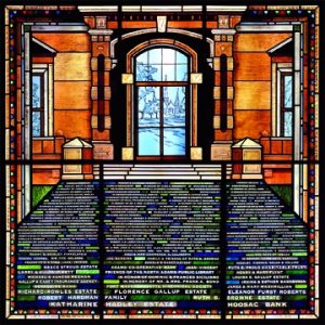
Coombs, Debora . “North Adams Public Library.” Debora Coombs stained glass. Accessed October 15, 2017. http://coombscriddle.com/artwork/2437806_North_Adams_Public_Library.html.

Susannah and I are making steady progress toward our final goal.  We took a trip to the local library last week and found some promising sources on a few prominent Irish immigrants to the area during the late 1800s.  We are also starting to create our pages for our project site and are currently figuring out where we want what information to go where.  We plan on going back to the library either this week or next week to try and find more primary sources.  We are also still adding information to our google map and our timeline to make them as full as possible because we want them to be a sort of center point on our project site.  They are some of the most visual pieces and are also our most interactive elements of the project so people will most likely gravitate to them first, so we want them to be the best they can possibly be.

Project Progress

Our project is coming along steadily, we have created a google my maps and timeline to visually show readers the journey that thousands of Irish settlers took from 1840 through 1900.  I created a page on our project site for them entitled Helpful Maps of the Irish Journey which I think looks very visually appealing.   The only problem I can foresee people encountering is the fact that when you try to scroll down the page with the mouse hovering over the google my maps, it just zooms in or out and can make the map look really strange.  It is an easy and quick fix for people to realize that is what is happening but it can also be a bit startling when it happens, I speak from experience.  I am also still working on the name of the page because I am not sure if I want to include Immigrants in it or not yet or just keep it at Irish, I do not want it to sound like we are talking about all Irish citizens but I do not want to refer to them as immigrants too often.

As for sources go we have been finding really great secondary sources but not to many primary sources, which has been kind of frustrating but we are trying really hard to scout them out.   Figuring out how to cite work has been a bit confusing but using the citation machine that Amy suggested in Slack has been very helpful.

Cultural Crossroads Final Contract

Project Site:http://xroads.coplacdigital.org/mcla/

Project Description (Mission Statement and Goal):

The goal of this project is to increase understanding of the Irish workers who built the town of North Adams, from the 1840s through the beginning of the 20th century, among local residents.  We intend for our website to be as user friendly as possible and tell the story of the Irish in the Berkshires as succinctly as possible.  We would love for our project to be used by the North Adams Historical Society as an exhibit of the amazing history of our area.  We would also love our site to help anyone who is looking to research the history of Irish migration to America along with North Adams specific history.  Our project is unique in the fact that while many people have studied the history of the Irish in America and specifically in New England, this is the first online digital history project on Irish Immigrants in the Berkshires their seems to have ever been.  We would love for our project to be a useful tool for anyone with a love of local history to be able to widen their understanding of an amazing group of people who faced incredible odds and came out for the better.

Basic Structure of Website:

The homepage of the website will feature beautiful images relating to the project as well as a summary of our project and it’s goals. We will also have pages devoted to our bios, our secondary bibliography, our primary bibliography, project contract, the timeline, and the map, and a page devoted to significant events in chronological order to better illustrate the story we are telling.

Tools We Are Using:

We are using a wordpress site with the Hemingway theme. We will also be using Timeline JS and Google My Map to trace the Irishmen’s journey to and around the Berkshires.

Work to be complete by each member:

Kate- Responsible for 3 Primary sources and 4 Secondary sources, transportation to and from archives, finding images to be used for the site, as well as creating the pages our information will be entered into and setting up the website.

Susannah- Responsible for 3 Primary sources and 4 Secondary sources, contacting archives to set up additional help, finding any potential videos or audio clips to be used in our site, entering information onto pages as well as finalizing the overall look of the website.

Schedule for Milestone:

  • October 3, 2017 – First drafts at Google My Map and Timeline to be posted on individual and project blog.
  • October 5, 2017 – Final Draft of Contract
  • November 20, 2017 Final Draft of Bibliographies
  • November 28-30, 2017 – Final Presentations
  • December 11, 2017 – Final Websites and Blogging due

Google My Maps

“Trinity College Dublin.” IE 2050: The History of Irish Cartography – Courses – Irish Studies – School Of Histories And Humanities – Trinity College Dublin. Accessed October 02, 2017. https://www.tcd.ie/courses/irishstudies/courses/cartography.php.

Click on the picture to view our map!

Susannah and I choose to use Google My Maps to show the journey of the Irish out of Ireland to North Adams.  We used news paper and online sources as well as the birth place listed on a few grave stones to locate where these families were from in Ireland and where they stopped along the way to their new home.